Geography and History: A Map-Based Inquiry
Guiding Question
How has geography influenced economic development, population trends, and historical events in the U.S.?
Objectives
- Students will interpret and synthesize information from historical maps.
- Students will make claims about historical trends based on geographic data.
- Students will draw conclusions about regional differences and changes over time.
- Students will answer prompts by creating a claim and line of reasoning supported by evidence.
Student Resources:
Teacher Resources:
- A Map Based Inquiry Teacher Resource
- Station Setup Guide
- Prompt Cards
- Map Set
- (Optional) Reading Maps Like a Historian Anchor Chart Teacher Resource
Facilitation Notes
- This is a group station activity. Prior to class, prepare maps and inquiry prompt cards. Ensure each station has the necessary resources. Support for setting up the stations is included in the A Map Based Inquiry Teacher Resource.
- The Anticipate section of the lesson includes a couple of different ways to build either background knowledge or map analysis skills with students before engaging in the rest of the lesson. Choose one or more activities based on student needs and time available.
Anticipate
Option 1: KWL Chart – Geography and U.S. History
- Ask students to complete a quick KWL chart:
- K – What do I already know about how geography has shaped U.S. history?
- W – What do I want to learn or wonder?
- L – What have you learned through the activity?
- Leave L blank for now and revisit at the end of the lesson.
- Use responses to highlight prior knowledge and guide class discussion before starting the mini-lesson.
Option 2: How to Read Maps Like a Historian Mini-lesson
- Hook
- Say: Maps are more than just directions-they tell stories. Today you’re historians, and your job is to read maps like clues in a mystery.
- Model
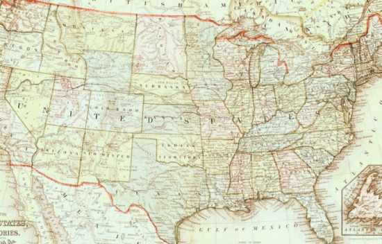
- Project a map (For example: Topography Map). Think aloud:
- This map shows topography, or landforms, of the United States. What symbols do we see-what landforms to they represent?
- Highlight rivers, mountains, or oceans around the map.
- I notice the Great Plains are located in the Mid-west. What are the Great Plains like?
- Circle the region on the map and ask:
- What does the geography here offer? What kinds of industries might we find here?
- This map shows topography, or landforms, of the United States. What symbols do we see-what landforms to they represent?
- Project a map (For example: Topography Map). Think aloud:
- Student Practice
- Hand out or display a different map (For example: U.S. Population Over Time Density or Railroads as of 1869).
- Ask:
- What do you notice?
- Where are the clusters or empty spots?
- What might this map tell us about life in that region?
- Ask:
- Have students turn and talk, using the sentence starter:
- “I think this map is showing us ____, and I noticed _____, which might mean _____.”
- Hand out or display a different map (For example: U.S. Population Over Time Density or Railroads as of 1869).
Scaffolding note: Consider using the following AI prompt to provide further scaffolds for students requiring additional vocabulary support.
- “Create a simple bilingual glossary with definitions and visuals for these terms from a U.S. history geography lesson: territory expansion, economy, agriculture, population, railroad, topography.”
Scaffolding note: Consider using the following AI prompt to provide further scaffolds for students requiring visual and graphic organizer support.
- “Design a visual scaffold to help students analyze a map and identify cause-and-effect relationships between geography and historical events.”
Engage
- Display the first inquiry card on the board. Model a think-aloud for students to demonstrate how to analyze the question to determine what they will be looking for in the map.
- Ask guiding questions such as:
- What is this question asking?
- Which maps would provide evidence?
- What do I observe? What do I infer?
- Ask guiding questions such as:
- Demonstrate using the map to write a well-supported response using the thesis framework from our Deconstructed DBQ resources:
- Claim: Clearly state your assertion.
- Reason: Provide a line of reasoning to support your claim.
- Evidence: Cite specific information from the map that supports the claim and reason.
- For example:
- Claim: Cities are most likely to develop near bodies of water.
- Line of Reasoning: Such as rivers, lakes, and oceans.
- Evidence: Of 10 cities on the Topography Map, only 2 are not near a body of water.
- For example:
Scaffolding note: Reference resources from Unit 1: Deconstructed DBQ for more support teaching this framework.
Explore
- Organize students into small groups (2-3). Students then engage in a station rotation or in stationary groups to review the inquiry prompts and map sets.
- Station Rotation Option:
- Each group begins at a different prompt station and rotates every 5-7 minutes.
- Instructions at each Station:
- Read the prompt: Discuss it within the group.
- Consult relevant maps: Encourage students to explore the maps thoroughly.
- Collaboratively write a claim: Use the Student Response Sheet to jot down their claim (1-2 sentences) supported with reasoning and geographic evidence.
- Stationary Groups Option:
- Provide a full set of maps to each group. Display the instructions on the board or print them for each group.
Scaffolding note: Alternatively, this activity can be completed digitally. Add the maps to a slide deck students can access and annotate online. Students can collaboratively complete the Student Response Sheet online as well.
- Move among the groups to provide support, ask probing questions, and encourage deeper thinking.
- Listen for misconceptions or overly general claims like “The West had no railroads.” Ask follow-up questions like:
- Which physical features, population, or territory expansion would support that activity?
- What specific map detail supports your claim?
- Encourage students to revise claims on the spot by modeling this quick sentence starter: “Let’s improve that by adding a geographic detail from the map.”
- Listen for misconceptions or overly general claims like “The West had no railroads.” Ask follow-up questions like:
Scaffolding note: Consider using the following AI prompts to provide further scaffolds for students requiring language scaffolds and support with comprehensible input.
- “Rewrite these inquiry prompts at a 4th-grade reading level for students with emerging English proficiency.”
- “Generate simplified thesis sentence starters for students with limited English proficiency who are analyzing historical maps.”
Scaffolding note: Consider using the following AI prompts to provide further scaffolds for students requiring scaffolds for cognitive processing or working memory challenges.
- “Suggest chunking strategies and step-by-step guide sheets to help a student with executive functioning challenges complete a multi-map inquiry station activity.”
- “Provide a simplified checklist that a student with processing delays could use to work through a geography and history map analysis task.”
Assess & Reflect
- Formative Assessment:
- Partner Discussions: Have students share their claims with a partner at each station, providing feedback on each other’s reasoning.
- Teacher Check-Ins: Circulate and ask guiding questions to assess understanding and encourage critical thinking.
AND/OR
- Summative Assessment:
- Exit Claim: As a class, choose one of the following complex prompts for an independent exit claim. Each student must:
- Write a claim using the Thesis format (Claim+ Line of Reasoning) and cite at least three pieces of evidence from different maps.
- Submit their Student Response Sheet.
- Prompt choices:
- Identify the city described in the following scenario: This city is located in a state that became part of the United States in 1803 but was not one of the original thirteen colonies. It earned the nickname “Gateway to the West” because of its position at the meeting point of two major rivers and two key railroad lines. These transportation routes helped the city grow rapidly. Today, its population density is high-up to 90 people per square mile.
- Identify the city described in the following scenario: This area became a U.S. territory in 1869 after being acquired from Mexico. It has no major rivers or lakes and was not served by railroads in the 19th century. Its dry climate and remote location limited early settlement and development.
Scaffolding note: Consider using the following AI prompts to modify assessment prompts or design an alternate task.
- “Create a modified version of the map analysis exit ticket for a student with a reading comprehension IEP goal. Include visuals and sentence stems.”
- “Design an alternate assessment for a student with an IEP goal related to oral expression. How can they demonstrate understanding of map-based historical analysis verbally?”
Optional Peer Review:
- Before submitting, have students exchange their exit claims with a peer for feedback on the clarity of their claims, quality of evidence, and strength of reasoning.
- Use the following rubric to assess their peer’s work, focusing on clarity, evidence, and reasoning.
| Criteria | 3 = Strong | 2 = Developing | 1 = Needs Revision |
| Claim | Clear, specific, answers the question | Partially answers the question | Vague or unclear |
| Reasoning | Clearly connects evidence to claim | Partial explanation | Reasoning missing or unclear |
| Evidence | At least two relevant and specific map details | One piece of evidence or somewhat vague | No clear evidence |